# Diplomat
Diplomat prepares your interactive map for an international audience. With a few lines of code, your [MapLibre GL JS](https://github.com/maplibre/maplibre-gl-js/)–powered map will speak the user’s preferred language while informing them about local languages the world over.
| Before | After |
| ---------------------------------------------------------------------------------------------------------------------- | -------------------------------------------------------------------------------------------------------------------------------------------------------------------------------------- |
| 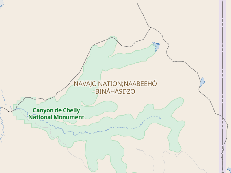 | [
| [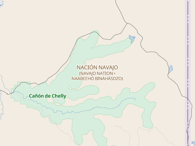 ](https://americanamap.org/#map=9/36.2134/-109.2837&language=es) |
|
](https://americanamap.org/#map=9/36.2134/-109.2837&language=es) |
| 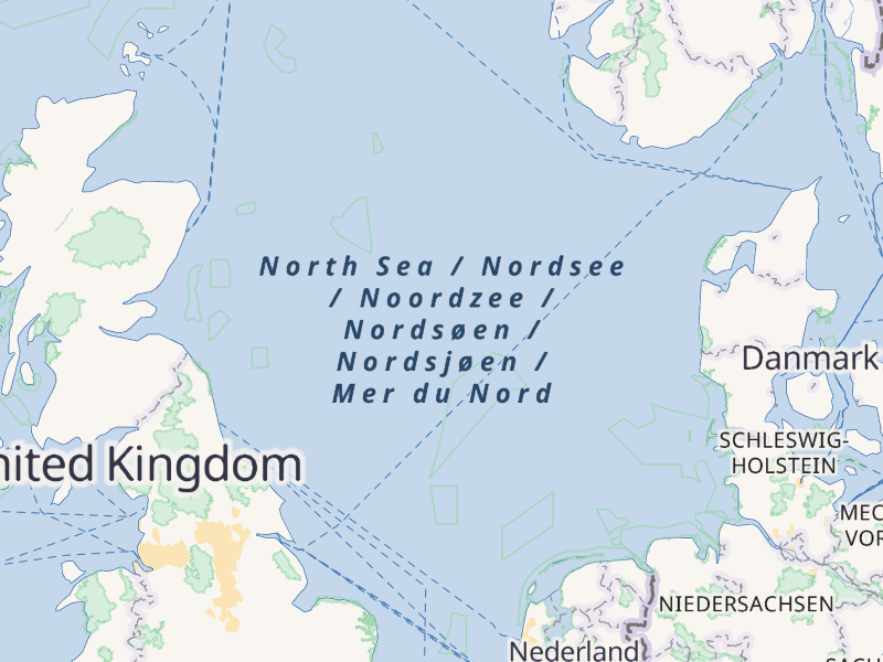 | [
| [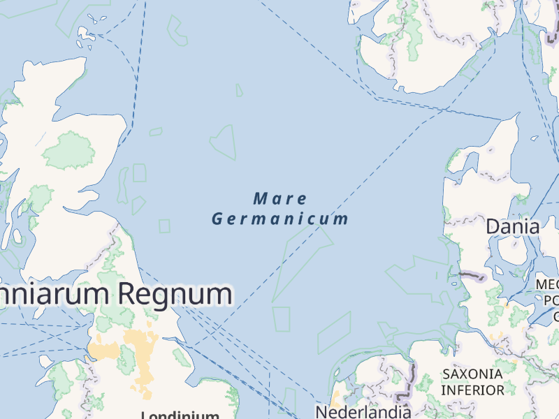 ](https://americanamap.org/#map=4/56/3&language=la) |
|
](https://americanamap.org/#map=4/56/3&language=la) |
| 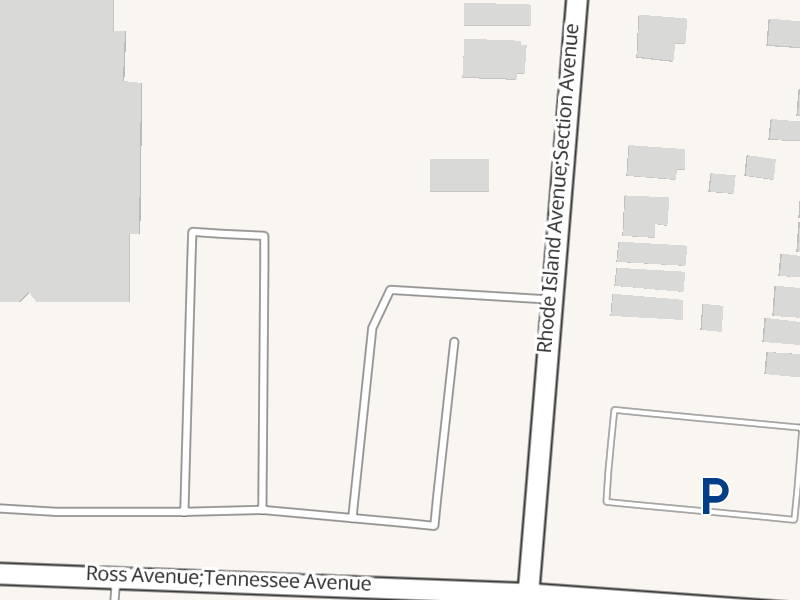 | [
| [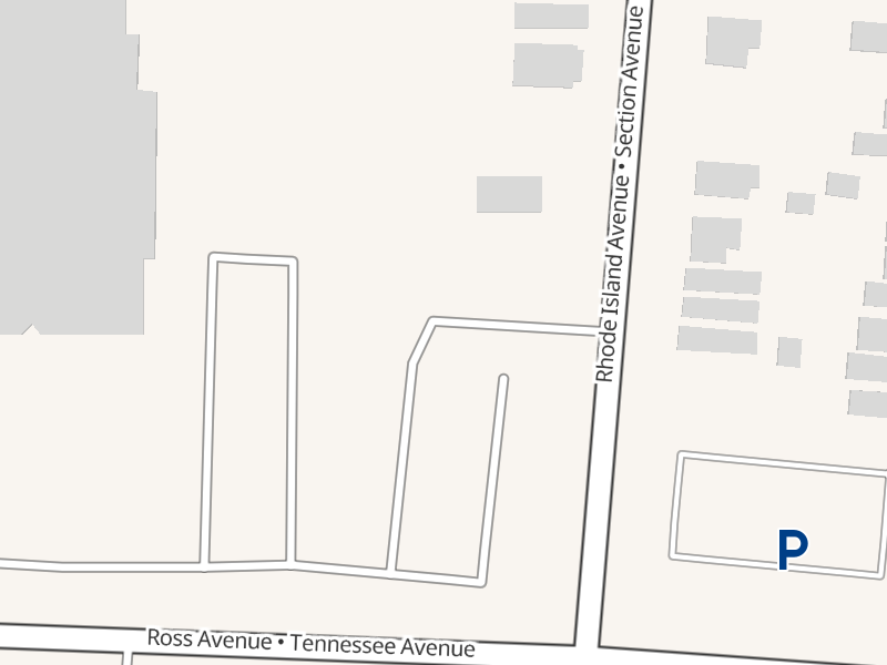 ](https://americanamap.org/#map=17/39.168568/-84.460075) |
## Features
Diplomat gives all parties a win-win:
- Tailors labels to the user’s preferred language.
- Respects multilingualism with optional dual language labels: both the user’s preferred language and the local native language.
- Recognizes any language, dialect, or script out of the box with sophisticated language code matching.
Diplomat lets your designer save face:
- Uses space efficiently with both multiline and inline label layouts.
- Deduplicates names within a label to avoid clutter.
- Preserves diacritics in English exonyms where appropriate.
- Respects right-to-left and vertical text layouts.
Diplomat works quietly behind the scenes:
- Changes the style on the fly at runtime – no need to publish a new style or tileset for every language.
- You choose which style layers to localize, or localize them all automatically.
- Supports multiple popular vector tile schemas without hacky workarounds, plus custom vector tilesets and GeoJSON sources.
All localization is subject to the availability of localized names in the map data source. See [the caveats](#caveats) for more details.
## Requirements
Diplomat is compatible with applications using MapLibre GL JS v5.22.0 and above.
The stylesheet must use the newer [expression](https://maplibre.org/maplibre-style-spec/expressions/) syntax; [legacy style functions](https://maplibre.org/maplibre-style-spec/deprecations/#function) are not supported. The stylesheet’s sources must conform to [Diplomat’s schema](#schema). Several popular vector tilesets already conform to this schema, including:
- [OpenMapTiles](https://openmaptiles.org/schema/) implementations, e.g., [MapTiler](https://cloud.maptiler.com/tiles/v3-openmaptiles/), [OpenFreeMap](https://openfreemap.org/), [OpenStreetMap U.S.](https://tiles.openstreetmap.us/vector/openmaptiles/), [Stadia Maps](https://docs.stadiamaps.com/vector/)
- [Tilezen](https://tilezen.readthedocs.io/en/latest/layers/) implementations, e.g., [Protomaps](https://protomaps.com/)
With additional configuration, Diplomat supports even more vector tilesets, including:
- [Mapbox Streets](https://docs.mapbox.com/data/tilesets/reference/mapbox-streets-v8/#names)
- [OpenHistoricalMap](https://wiki.openstreetmap.org/wiki/OpenHistoricalMap/Reuse#Vector_tiles)
- [Shortbread](https://shortbread-tiles.org/schema/) implementations, e.g., [OpenStreetMap.org](https://vector.openstreetmap.org/), [VersaTiles](https://github.com/versatiles-org/versatiles-generator/)
## Installation
This plugin is available as [an NPM package](https://www.npmjs.com/package/@americana/diplomat). To install it, run the following command:
```sh
npm install @americana/diplomat
```
Alternatively, you can include the plugin as a standalone script from a CDN such as [unpkg](https://unpkg.com/@americana/diplomat/index.js).
## Usage
Import Diplomat as a module:
```js
import * as Diplomat from "@americana/diplomat";
```
After creating an instance of `maplibregl.Map`, register an event listener for the `styledata` event that localizes the map:
```js
map.once("styledata", (event) => {
Diplomat.localizeStyle(map);
});
```
If your stylesheet uses a tileset that formats the name keys differently, such as OpenHistoricalMap or Shortbread, set the format when localizing the layers, for example:
```js
map.once("styledata", (event) => {
let locales = Diplomat.getLocales();
Diplomat.localizeStyle(map, locales, {
localizedNamePropertyFormat: "name_$1",
});
});
```
If you set the `hash` option to a string when creating the `Map`, you can have this code respond to a `language` parameter in the URL hash. Add a window event listener for whenever the hash changes, in order to update the layers:
```js
addEventListener("hashchange", (event) => {
let oldLanguage = Diplomat.getLanguageFromURL(new URL(event.oldURL));
let newLanguage = Diplomat.getLanguageFromURL(new URL(event.newURL));
if (oldLanguage !== newLanguage) {
Diplomat.localizeStyle(map);
}
});
```
Similarly, you can immediately respond to any change the user makes to their browser language preference in real time:
```js
addEventListener("languagechange", (event) => {
Diplomat.localizeStyle(map);
});
```
> [!NOTE]
> By default, MapLibre GL JS does not support bidirectional text. Arabic, Hebrew, and other right-to-left languages will be unreadable unless you [install the mapbox-gl-rtl-text plugin](https://maplibre.org/maplibre-gl-js/docs/examples/add-support-for-right-to-left-scripts/).
## Schema
Diplomat can manipulate any GeoJSON or vector tile source, as long as it includes the following properties on each feature:
- **`name`** (`string`): The name in the local or official language. You can customize this property by setting the `unlocalizedNameProperty` option when calling [`maplibregl.Map.prototype.localizeStyle()`](#maplibreglmapprototypelocalizestyle).
- **
](https://americanamap.org/#map=17/39.168568/-84.460075) |
## Features
Diplomat gives all parties a win-win:
- Tailors labels to the user’s preferred language.
- Respects multilingualism with optional dual language labels: both the user’s preferred language and the local native language.
- Recognizes any language, dialect, or script out of the box with sophisticated language code matching.
Diplomat lets your designer save face:
- Uses space efficiently with both multiline and inline label layouts.
- Deduplicates names within a label to avoid clutter.
- Preserves diacritics in English exonyms where appropriate.
- Respects right-to-left and vertical text layouts.
Diplomat works quietly behind the scenes:
- Changes the style on the fly at runtime – no need to publish a new style or tileset for every language.
- You choose which style layers to localize, or localize them all automatically.
- Supports multiple popular vector tile schemas without hacky workarounds, plus custom vector tilesets and GeoJSON sources.
All localization is subject to the availability of localized names in the map data source. See [the caveats](#caveats) for more details.
## Requirements
Diplomat is compatible with applications using MapLibre GL JS v5.22.0 and above.
The stylesheet must use the newer [expression](https://maplibre.org/maplibre-style-spec/expressions/) syntax; [legacy style functions](https://maplibre.org/maplibre-style-spec/deprecations/#function) are not supported. The stylesheet’s sources must conform to [Diplomat’s schema](#schema). Several popular vector tilesets already conform to this schema, including:
- [OpenMapTiles](https://openmaptiles.org/schema/) implementations, e.g., [MapTiler](https://cloud.maptiler.com/tiles/v3-openmaptiles/), [OpenFreeMap](https://openfreemap.org/), [OpenStreetMap U.S.](https://tiles.openstreetmap.us/vector/openmaptiles/), [Stadia Maps](https://docs.stadiamaps.com/vector/)
- [Tilezen](https://tilezen.readthedocs.io/en/latest/layers/) implementations, e.g., [Protomaps](https://protomaps.com/)
With additional configuration, Diplomat supports even more vector tilesets, including:
- [Mapbox Streets](https://docs.mapbox.com/data/tilesets/reference/mapbox-streets-v8/#names)
- [OpenHistoricalMap](https://wiki.openstreetmap.org/wiki/OpenHistoricalMap/Reuse#Vector_tiles)
- [Shortbread](https://shortbread-tiles.org/schema/) implementations, e.g., [OpenStreetMap.org](https://vector.openstreetmap.org/), [VersaTiles](https://github.com/versatiles-org/versatiles-generator/)
## Installation
This plugin is available as [an NPM package](https://www.npmjs.com/package/@americana/diplomat). To install it, run the following command:
```sh
npm install @americana/diplomat
```
Alternatively, you can include the plugin as a standalone script from a CDN such as [unpkg](https://unpkg.com/@americana/diplomat/index.js).
## Usage
Import Diplomat as a module:
```js
import * as Diplomat from "@americana/diplomat";
```
After creating an instance of `maplibregl.Map`, register an event listener for the `styledata` event that localizes the map:
```js
map.once("styledata", (event) => {
Diplomat.localizeStyle(map);
});
```
If your stylesheet uses a tileset that formats the name keys differently, such as OpenHistoricalMap or Shortbread, set the format when localizing the layers, for example:
```js
map.once("styledata", (event) => {
let locales = Diplomat.getLocales();
Diplomat.localizeStyle(map, locales, {
localizedNamePropertyFormat: "name_$1",
});
});
```
If you set the `hash` option to a string when creating the `Map`, you can have this code respond to a `language` parameter in the URL hash. Add a window event listener for whenever the hash changes, in order to update the layers:
```js
addEventListener("hashchange", (event) => {
let oldLanguage = Diplomat.getLanguageFromURL(new URL(event.oldURL));
let newLanguage = Diplomat.getLanguageFromURL(new URL(event.newURL));
if (oldLanguage !== newLanguage) {
Diplomat.localizeStyle(map);
}
});
```
Similarly, you can immediately respond to any change the user makes to their browser language preference in real time:
```js
addEventListener("languagechange", (event) => {
Diplomat.localizeStyle(map);
});
```
> [!NOTE]
> By default, MapLibre GL JS does not support bidirectional text. Arabic, Hebrew, and other right-to-left languages will be unreadable unless you [install the mapbox-gl-rtl-text plugin](https://maplibre.org/maplibre-gl-js/docs/examples/add-support-for-right-to-left-scripts/).
## Schema
Diplomat can manipulate any GeoJSON or vector tile source, as long as it includes the following properties on each feature:
- **`name`** (`string`): The name in the local or official language. You can customize this property by setting the `unlocalizedNameProperty` option when calling [`maplibregl.Map.prototype.localizeStyle()`](#maplibreglmapprototypelocalizestyle).
- **name:xyz** (`string`): The name in another language, where xyz is a valid [IETF language tag](https://en.wikipedia.org/wiki/IETF_language_tag). For example, name:zh for Chinese, name:zh-Hant for Traditional Chinese, name:zh-Hant-TW for Traditional Chinese (Taiwan), and name:zh-Latn-pinyin for Chinese in pinyin. You can customize this format by setting the `localizedNamePropertyFormat` option when calling [`maplibregl.Map.prototype.localizeStyle()`](#maplibreglmapprototypelocalizestyle).
For compatibility with the [OpenMapTiles](https://openmaptiles.org/schema/) schema, `name_en` and `name_de` are also recognized as alternatives to `name:en` and `name:de` for English and German, respectively, but only in the `transportation_name` layer. For performance reasons, Diplomat does not look for this format by default for any other language or layer.
Each of the supported properties may be set to a list of values separated by [semicolons](https://wiki.openstreetmap.org/wiki/Semi-colon_value_separator). For example, if a place speaks both English and French, `name` should be `English Name;French Name`. Similarly, if a landmark has three equally common names in Spanish, regardless of dialect, `name:es` should be `Nombre Uno;Nombre Dos;Nombre Tres`. The list can contain an unlimited number of values. In the rare case that a single name contains a semicolon, it should be escaped as a double semicolon (`;;`).
The original underlying data source (e.g., OpenStreetMap) may follow a different set of conventions as long as the GeoJSON or vector tile source translates it to this schema.
## API
This plugin adds several symbols to a `maplibregl.Diplomat` namespace and adds a single method to each instance of `maplibregl.Map`. The following documentation uses the notation `maplibregl.Diplomat.*` in case you include Diplomat as a script. However, if you import Diplomat as a module, these symbols are directly imported into your code, without any namespacing.
### `maplibregl.Diplomat.localizedName`
An expression that produces the names in the user's preferred language, each on a separate line.
Use this constant if you are building the entire stylesheet programmatically before initializing a `maplibregl.Map` and want more fine-grained control over which layers have which label layout than [`maplibregl.Map.prototype.localizeStyle()`](#maplibreglmapprototypelocalizestyle) provides.
This expression is appropriate for labeling a type of feature that almost always has a familiar translation in the user’s preferred language, such as the name of a country. It is also appropriate for minor features like points of interest, for which an extra local-language gloss would clutter the map.
Example:
```js
map.setLayoutProperty(
"country-labels",
"text-field",
maplibregl.Diplomat.localizedName,
);
```
### `maplibregl.Diplomat.localizedNameInline`
An expression that produces the names in the user's preferred language, all on the same line.
Use this constant if you are building the entire stylesheet programmatically before initializing a `maplibregl.Map` and want more fine-grained control over which layers have which label layout than [`maplibregl.Map.prototype.localizeStyle()`](#maplibreglmapprototypelocalizestyle) provides.
This expression is appropriate for labeling a linear feature, such as a road or waterway. The symbol layer’s [`symbol-placement`](https://maplibre.org/maplibre-style-spec/layers/#symbol-placement) layout property should be set to either `line` or `line-center`.
Example:
```js
map.setLayoutProperty(
"road-labels",
"text-field",
maplibregl.Diplomat.localizedNameInline,
);
```
### `maplibre.Diplomat.localizedNameWithLocalGloss`
An expression that produces the name in the user's preferred language, followed by the name in the local language in parentheses if it differs.
Use this constant if you are building the entire stylesheet programmatically before initializing a `maplibregl.Map` and want more fine-grained control over which layers have which label layout than [`maplibregl.Map.prototype.localizeStyle()`](#maplibreglmapprototypelocalizestyle) provides.
This expression is appropriate for labeling a type of feature that is only sometimes translated into user’s preferred language, such as the name of a city or town. The extra local-language gloss respects local customs and keeps the user informed, but it can also risk [information overload](https://en.wikipedia.org/wiki/Information_overload) and crowd out other useful labels.
Example:
```js
map.setLayoutProperty(
"city-labels",
"text-field",
maplibregl.Diplomat.localizedNameWithLocalGloss,
);
```
### `maplibregl.Diplomat.getLocalizedCountryNameExpression()`
Returns an expression that converts the given country code to a human-readable name in the user's preferred language.
This method is useful for stylesheets powered by OpenMapTiles, which only provides the ISO 3166-1 alpha-3 code of the country on either side of a boundary, but not the full country name in any language.
Parameters:
- **`code`** (`string`): An expression that evaluates to an ISO 3166-1 alpha-3 country code.
Example:
```js
map.setLayoutProperty(
"boundary-edge-labels",
"text-field",
maplibregl.Diplomat.getLocalizedCountryNameExpression(["get", "adm0_l"]),
);
```
> [!NOTE]
> Use [`maplibregl.Diplomat.getGlobalStateForLocalization()`](#maplibregldiplomatgetglobalstateforlocalization) to populate the global state required by this expression, then call [`maplibregl.Map.prototype.localizeStyle()`](#maplibreglmapprototypelocalizestyle). Otherwise, this expression evaluates to the raw country code.
### `maplibregl.Diplomat.getGlobalStateForLocalization()`
Returns the global state that Diplomat needs to fully localize the style.
If you are building a stylesheet programmatically, you can use this method to populate a `state` property at the root of the stylesheet before initializing a `maplibregl.Map`. You can add additional global state properties besides the ones that come from this object, as long as you avoid making a deep clone of the object.
If your stylesheet is powered by OpenMapTiles, you need to set this global state object in order to localizing boundary edge labels that come from the [`boundary`](https://openmaptiles.org/schema/#boundary) layer. Otherwise, the user will see only ISO 3166-1 alpha-3 codes, because OpenMapTiles only provides these codes instead of the full country name on either side of a boundary.
Parameters:
- **`locales`** (`string`): The locales for formatting the country names.
- **`options.uppercaseCountryNames`** (`boolean`): Whether to write the country names in all uppercase, respecting the locale’s case conventions. Enable this option if you intend to display the boundary edge labels in uppercase, because the `upcase` expression operator is locale-insensitive.
Example:
```js
map.once("styledata", (event) => {
let localizationState = maplibregl.Diplomat.getGlobalStateForLocalization(
getLocales(),
{
uppercaseCountryNames: true,
},
);
for (let [key, value] of Object.entries(localizationState)) {
map.setGlobalStateProperty(key, value);
}
});
```
### `maplibregl.Diplomat.getLocales()`
Returns the languages that the user prefers.
Example:
```js
maplibregl.Diplomat.getLocales().includes("en");
```
### `maplibregl.Diplomat.getRelatedLanguageTags()`
Returns an array of the language tags related to the given language tag, sorted from most specific to least specific.
Parameters:
- **`tag`** (`string`): The language tag that the returned language tags are related to.
Returns a sorted array of related language tags, or an empty array if `tag` is malformed.
Example:
```js
maplibregl.Diplomat.getRelatedLanguageTags("sr-RS").includes("sr-Cyrl");
maplibregl.Diplomat.getRelatedLanguageTags("zh").includes("zh-Hans-CN");
```
### `maplibregl.Diplomat.localizeStyle()`
Updates each style layer's `text-field` value to match the given locales, upgrading any unlocalizable layer along the way.
If neither `options.layers` nor `options.sourceLayers` is specified in `options`, this function makes localizable any style layer that gets the feature property specified in `options.unlocalizedNameProperty`, or `name` by default.
Parameters:
- **`map`** (`maplibregl.Map`): The map to localize.
- **`locales`** (`[string]`): The locales to insert into each layer, as a comma-separated list of [IETF language tags](https://en.wikipedia.org/wiki/IETF_language_tag). Uses the `language` URL hash parameter or browser preferences by default.
- **`options`** (`object`):
- **`layers`** (`[string]`): The style layers with these IDs will be made localizable.
- **`sourceLayers`** (`[string]`): The style layers that use these source layers will be made localizable. These are source layer IDs, not style layer IDs.
- **`unlocalizedNameProperty`** (`string`): The name of the property holding the unlocalized name. `name` by default.
- **`localizedNamePropertyFormat`** (`string`): The format of properties holding localized names, where `$1` is replaced by an IETF language tag. `name:$1` by default.
- **`glossLocalNames`** (`boolean`): Whether to format each label as a dual language label including a local name gloss.
- **`uppercaseCountryNames`** (`boolean`): Whether to write country names in all uppercase, respecting the locale’s case conventions.
Example:
```js
maplibregl.Diplomat.localizeStyle(map, ["eo"], {
sourceLayers: ["place"],
glossLocalNames: true,
});
```
### `maplibregl.Map.prototype.localizeStyle()`
A wrapper for [`maplibregl.Diplomat.localizeStyle()`](#maplibregldiplomatlocalizestyle) that does not require passing in a `maplibregl.Map`. Only available when including Diplomat as a script.
Example:
```js
map.localizeStyle(["eo"], {
localizedNamePropertyFormat: "name_$1",
});
```
## Caveats
Diplomat only switches between languages that are present in the stylesheet’s data sources. It does not fetch translations from other sources or generate its own transliterations. By convention, [OpenStreetMap’s coverage in some regions](https://wiki.openstreetmap.org/wiki/Multilingual_names) is largely limited to locally spoken languages. If you need more comprehensive coverage in a given language, consider using a tileset that combines names from OpenStreetMap and Wikidata, such as the [OpenStreetMap U.S. Tileservice](https://tiles.openstreetmap.us/vector/openmaptiles/).
By default, MapLibre GL JS does not support bidirectional text. Arabic, Hebrew, and other right-to-left languages will be unreadable unless you [install the mapbox-gl-rtl-text plugin](https://maplibre.org/maplibre-gl-js/docs/examples/add-support-for-right-to-left-scripts/).
Diplomat performs basic language fallbacks according to the [ICU locale fallback algorithm](https://unicode-org.github.io/icu/userguide/locale/#fallback). Additionally, it implements the [Likely Subtags](https://www.unicode.org/reports/tr35/#Likely_Subtags) algorithm of Unicode Technical Standard #35, so for example requesting either `zh` or `cmn` returns a name tagged as `zh-Hans-CN`, among other variations. However, in general, it does not fall back to a related but distinct language code, such as from `sr-Cyrl` to `ru` or from `nb` to `no`. Instead, the user can [set their preferred languages](https://www.w3.org/International/questions/qa-lang-priorities) in their browser or operating system settings.
For historical reasons, [OpenStreetMap’s coverage in many regions](https://wiki.openstreetmap.org/wiki/Multilingual_names) encodes multiple local names separated by human-readable punctuation. Diplomat makes no attempt to guess which punctuation is part of a name and which punctuation delimits two names.
## Acknowledgments
This plugin was spun out of the [OpenStreetMap Americana](https://github.com/osm-americana/openstreetmap-americana/) project. It was originally inspired by [Mapbox GL Language](https://github.com/mapbox/mapbox-gl-language/).